As everybody knows by now (or at least, as everybody who’s ever read our ‘History of the Wyre from Harold the Elk to Cardinal Allen’ knows by now) the hamlet of Nateby plays host to a number of prehistoric earthworks. These range from Romano/British roads and farmsteads, to Bronze Age pile settlements, Iron Age henges and banjo settlements. Further down the road, however, (we're keeping the exact location under wraps for now until the landowner gives us permission to post it) is another collection of earthworks that, so far, have never been documented. That they’re connected to Nateby in some fashion seems highly likely, but exactly what they are has yet to be decided.
With this in mind, a couple of weeks ago Neil Thompson (who seems to be related to every single person living in the Over Wyre district, and possibly one or two sheep as well) was given permission to investigate. Trust me, if you’re thinking about conducting your own investigation (assuming, of course, that you know where the earthwoks are) then you’d better make sure you’ve been granted permission as well, because the field is home to a herd of bulls and, therefore, surrounded by an electric fence. (Neil chose to ignore this minor detail when attempting a short cut back to the farmhouse much to the cost of the now singed spot on the back of his head.)
It wasn’t the best of afternoons to be wading through churned up cow manure and mud, it must be said, the sudden downpours not conducive to our digital cameras. Nonetheless, we managed to capture a few confusing images, one of which is reproduced below.
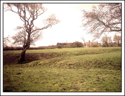
The field is full of these pronounced, regular and yet complicated ditch and bank systems, which form some sort of overall structure, though God alone knows what. Neil’s best guess as to what they are is a Romano/British ranch. They bear a striking resemblance, apparently, to those discovered in the 1990s on the far side of Nateby where two suspected kralls are connected by a hollow way. Personally I couldn’t see it myself, although I’m not about to argue because I don’t have any better ideas.
Back home with dry socks and a mug of cocoa, a quick survey conducted on Mario Maps produced the following aerial photograph.

To my mind there’s no evidence here of interconnected cattle pens (although, at ground level, the ditches and banks are far more complicated than they appear from above). So, until such time as we can stick our spades in the ground, it’ll all have to remain a mystery. In the meantime, however, your own speculations can be sent to the usual address. And believe me we could do with a few suggestions as to what we might have here right about now.
With this in mind, a couple of weeks ago Neil Thompson (who seems to be related to every single person living in the Over Wyre district, and possibly one or two sheep as well) was given permission to investigate. Trust me, if you’re thinking about conducting your own investigation (assuming, of course, that you know where the earthwoks are) then you’d better make sure you’ve been granted permission as well, because the field is home to a herd of bulls and, therefore, surrounded by an electric fence. (Neil chose to ignore this minor detail when attempting a short cut back to the farmhouse much to the cost of the now singed spot on the back of his head.)
It wasn’t the best of afternoons to be wading through churned up cow manure and mud, it must be said, the sudden downpours not conducive to our digital cameras. Nonetheless, we managed to capture a few confusing images, one of which is reproduced below.
The field is full of these pronounced, regular and yet complicated ditch and bank systems, which form some sort of overall structure, though God alone knows what. Neil’s best guess as to what they are is a Romano/British ranch. They bear a striking resemblance, apparently, to those discovered in the 1990s on the far side of Nateby where two suspected kralls are connected by a hollow way. Personally I couldn’t see it myself, although I’m not about to argue because I don’t have any better ideas.
Back home with dry socks and a mug of cocoa, a quick survey conducted on Mario Maps produced the following aerial photograph.
To my mind there’s no evidence here of interconnected cattle pens (although, at ground level, the ditches and banks are far more complicated than they appear from above). So, until such time as we can stick our spades in the ground, it’ll all have to remain a mystery. In the meantime, however, your own speculations can be sent to the usual address. And believe me we could do with a few suggestions as to what we might have here right about now.


2 comments:
You have a great blog with genuine information on archaeology and prehistoric stuff. I read an article about archaeologists excavating the
href="http://knowledge-scoop.com/2007/02/01/archaeologists-excavate-the-village-of-stonehenge-builders/">Stonehenge Village, which I would like to share
with you and your readers - it's really a big step forward in unearthing the truth about the mysterious Stonehenge.
Thanks,
Linda
Linda,
Thanks for the link. I'll check it out shortly. Apologies for taking so long to respond. One of these days I'll learn how to use this computer properly...I hope.
Post a Comment