Here’s a note of caution, sounded by ‘The Survey of English Place Names Volume One’, for enthusiastic researchers plying their way through tithe-maps and/or mediaeval records: Don’t be fooled by Saxon place names because, sometimes, the features to which they refer are considerably older than they sound.
“What on earth are they rabbiting on about now?” you’re probably thinking. Well, let’s take the name ‘Stodfeldpool’ as an example, mentioned in mediaeval documents as being one of the boundary markers between the estates of Rossall and Bourne. As any good Saxon dictionary would no doubt inform you, a ‘stodfeld’ is a horse enclosure (i.e. a stud field) and ‘pool’, of course, is Wyre dialect for a brook or a stream. So we could be forgiven for believing that what we’re looking for here is ‘…the brook by the Saxon horse enclosure’.
But is it? (Of course it isn’t, otherwise why would we be asking the question?) Back to the ‘Survey of English Place Names’ and what they have to say on this matter: ‘Stodfalt meant ‘an enclosure for a stud of horses,’ and when we find the Saxons calling by this name the walled Roman enclosures of Aldborough, Lympne and Irthington, two (not mutually exclusive) explanations are possible. They may have actually used them as horse-folds, or they may merely have thought they looked like horse-folds.”
In other words the Saxons often referred to ancient enclosures that they didn’t understand simply as a ‘stodfolds’ because it was easier than trying to establish what the enclosure had actually been used for. (Saxons, as you’ve probably gathered, weren’t exactly big on archaeology.)
Naming ancient enclosures as ‘stodfolds’ by the Saxons was, apparently, a common practice and to these ends the survey furnishes us with a list of twelve typical ‘stodfold’ locations, all of which have Roman or Iron Age earthworks attached to them. We’re not going to repeat the list here as that would probably be amount to plagiarism, so if you’re interested in that sort of thing we suggest that you track down a copy of the survey for yourselves.
All of this, of course, is useful information to know when interpreting field maps. And with that in mind, let’s return to that mediaeval boundary dividing the Rossall estate from Bourne; a boundary that, until now, we’ve been unable to put in place due to all the locations mentioned in it having been lost over the centuries.
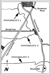
Now, in this particular instance, there are three likely candidates for ‘Stodfeldpool’. As the map on the right demonstrates, the first of these runs from Broadwater Wood down to Wyrefield Farm, New Mill recorded on Yates’ map of 1786 being somewhere in this area. The second possibility runs from Rossall Wood to Woodcock Wood. This stream, now a dyke, was (according to Neil Thompson) modified during the war for use as a tank trap...and we’ve no particular reason to doubt him. The third possibility, of course, is the dyke surrounding the northern slope of Bourne Hill, shown in the photograph below.
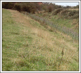
Obviously, because of what we found at Bourne in 2005, our money’s on the latter. The rectangular enclosure surrounding the Iron Age settlement on Bourne Hill’s summit could easily have been mistaken by the Saxons for a ‘stodfold’. In fact, even in the 1940s, the hill was still being used by Brian Pinney to contain his shire horses.
That almost all of the ‘stodfold’ enclosures mentioned by the ‘Survey of English Place Names’ stood on a Roman road is equally fascinating, especially considering that, to date, we haven’t managed to track down the Danes’ Pad in this neck of the woods. That hasn’t been for want of trying. In early May 2006, for example, accompanied by Neil Thompson and Ken Emery, we set out to track down this enigmatic highway once again at the rear of the Pheasant’s Wood housing estate. Unfortunately, true to form, we were ultimately disappointed. However the coincidences of ‘stodfolds’ falling alongside Roman roads does lend weight to the idea that the Danes Pad once ran through these parts, even if nowadays it’s seemingly been destroyed.
‘Stodfold’ isn’t the only Saxon description that was used for unknown earthworks, however. The word ‘Castle’ found on maps where no mediaeval castles were ever recorded generally refers to the ruins of walled enclosures, again more often than not either Iron Age or Roman. Castle Hill, just behind Hillylaid Road in Thornton, is one such example although with an Edwardian farm and a section of the ICI having previously covered a large part of it, we might never know exactly what the ‘castle’ was.
The word ‘Tunstead’ too, meaning literally ‘enclosed space’ but generally taken to mean ‘farmyard’ doesn’t necessarily refer to a Saxon building. Let’s return to the ‘Survey of English Place Names’ for their take on it: “All farmyards are enclosures, but not all enclosures are farmyards, and the word, like ‘studfold’, may sometimes refer to ancient Romano/British enclosures.”
Again the survey presents us with a list of examples which, for the same reasons cited above, we’re not going to include in this article. And again, it appears, where there’s an ‘ancient tunstead’ (as opposed to a genuine Saxon ‘tunstead’) there’s usually a Roman road near by.
Remember us mentioning a ‘tunstead’ in Thornton some time ago? Well, we’ve overlaid the aerial photograph of that particular field (it’s just behind the primary school if you’re interested) below with the tithe-map of Thornton from which we garnered this piece of information.
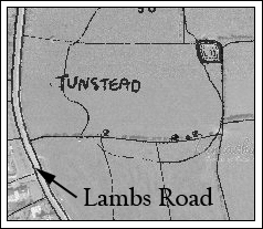
The original Saxon village (now the section of Raikes Road leading from Lambs Road to Thornton Hall Farm) is just off the bottom of the picture. As early field maps demonstrate the village had its own strip field system so it’s seems unlikely, perhaps, that this lone ‘tunstead’ field was an early farm.
In fact, some time ago, Neil Thompson informed us that he believed a Roman road cut across this field from the river bank, crossing the Wyre by a ford just north of Wardleys Creek. Another possibility takes us back to the article we posted last week concerning the age of Victoria Road and the fact that, if it was extended in a straight line, it would pass by ‘tunstead field’ before striking the cuttings of Bulker ford. Both, under the circumstances, are intriguing possibilities and we’re currently attempting to track down ‘tunstead’s owner. Keep your fingers crossed that we find them because an excavation in this area might prove far more interesting than we first imagined.
“What on earth are they rabbiting on about now?” you’re probably thinking. Well, let’s take the name ‘Stodfeldpool’ as an example, mentioned in mediaeval documents as being one of the boundary markers between the estates of Rossall and Bourne. As any good Saxon dictionary would no doubt inform you, a ‘stodfeld’ is a horse enclosure (i.e. a stud field) and ‘pool’, of course, is Wyre dialect for a brook or a stream. So we could be forgiven for believing that what we’re looking for here is ‘…the brook by the Saxon horse enclosure’.
But is it? (Of course it isn’t, otherwise why would we be asking the question?) Back to the ‘Survey of English Place Names’ and what they have to say on this matter: ‘Stodfalt meant ‘an enclosure for a stud of horses,’ and when we find the Saxons calling by this name the walled Roman enclosures of Aldborough, Lympne and Irthington, two (not mutually exclusive) explanations are possible. They may have actually used them as horse-folds, or they may merely have thought they looked like horse-folds.”
In other words the Saxons often referred to ancient enclosures that they didn’t understand simply as a ‘stodfolds’ because it was easier than trying to establish what the enclosure had actually been used for. (Saxons, as you’ve probably gathered, weren’t exactly big on archaeology.)
Naming ancient enclosures as ‘stodfolds’ by the Saxons was, apparently, a common practice and to these ends the survey furnishes us with a list of twelve typical ‘stodfold’ locations, all of which have Roman or Iron Age earthworks attached to them. We’re not going to repeat the list here as that would probably be amount to plagiarism, so if you’re interested in that sort of thing we suggest that you track down a copy of the survey for yourselves.
All of this, of course, is useful information to know when interpreting field maps. And with that in mind, let’s return to that mediaeval boundary dividing the Rossall estate from Bourne; a boundary that, until now, we’ve been unable to put in place due to all the locations mentioned in it having been lost over the centuries.
Now, in this particular instance, there are three likely candidates for ‘Stodfeldpool’. As the map on the right demonstrates, the first of these runs from Broadwater Wood down to Wyrefield Farm, New Mill recorded on Yates’ map of 1786 being somewhere in this area. The second possibility runs from Rossall Wood to Woodcock Wood. This stream, now a dyke, was (according to Neil Thompson) modified during the war for use as a tank trap...and we’ve no particular reason to doubt him. The third possibility, of course, is the dyke surrounding the northern slope of Bourne Hill, shown in the photograph below.
Obviously, because of what we found at Bourne in 2005, our money’s on the latter. The rectangular enclosure surrounding the Iron Age settlement on Bourne Hill’s summit could easily have been mistaken by the Saxons for a ‘stodfold’. In fact, even in the 1940s, the hill was still being used by Brian Pinney to contain his shire horses.
That almost all of the ‘stodfold’ enclosures mentioned by the ‘Survey of English Place Names’ stood on a Roman road is equally fascinating, especially considering that, to date, we haven’t managed to track down the Danes’ Pad in this neck of the woods. That hasn’t been for want of trying. In early May 2006, for example, accompanied by Neil Thompson and Ken Emery, we set out to track down this enigmatic highway once again at the rear of the Pheasant’s Wood housing estate. Unfortunately, true to form, we were ultimately disappointed. However the coincidences of ‘stodfolds’ falling alongside Roman roads does lend weight to the idea that the Danes Pad once ran through these parts, even if nowadays it’s seemingly been destroyed.
‘Stodfold’ isn’t the only Saxon description that was used for unknown earthworks, however. The word ‘Castle’ found on maps where no mediaeval castles were ever recorded generally refers to the ruins of walled enclosures, again more often than not either Iron Age or Roman. Castle Hill, just behind Hillylaid Road in Thornton, is one such example although with an Edwardian farm and a section of the ICI having previously covered a large part of it, we might never know exactly what the ‘castle’ was.
The word ‘Tunstead’ too, meaning literally ‘enclosed space’ but generally taken to mean ‘farmyard’ doesn’t necessarily refer to a Saxon building. Let’s return to the ‘Survey of English Place Names’ for their take on it: “All farmyards are enclosures, but not all enclosures are farmyards, and the word, like ‘studfold’, may sometimes refer to ancient Romano/British enclosures.”
Again the survey presents us with a list of examples which, for the same reasons cited above, we’re not going to include in this article. And again, it appears, where there’s an ‘ancient tunstead’ (as opposed to a genuine Saxon ‘tunstead’) there’s usually a Roman road near by.
Remember us mentioning a ‘tunstead’ in Thornton some time ago? Well, we’ve overlaid the aerial photograph of that particular field (it’s just behind the primary school if you’re interested) below with the tithe-map of Thornton from which we garnered this piece of information.
The original Saxon village (now the section of Raikes Road leading from Lambs Road to Thornton Hall Farm) is just off the bottom of the picture. As early field maps demonstrate the village had its own strip field system so it’s seems unlikely, perhaps, that this lone ‘tunstead’ field was an early farm.
In fact, some time ago, Neil Thompson informed us that he believed a Roman road cut across this field from the river bank, crossing the Wyre by a ford just north of Wardleys Creek. Another possibility takes us back to the article we posted last week concerning the age of Victoria Road and the fact that, if it was extended in a straight line, it would pass by ‘tunstead field’ before striking the cuttings of Bulker ford. Both, under the circumstances, are intriguing possibilities and we’re currently attempting to track down ‘tunstead’s owner. Keep your fingers crossed that we find them because an excavation in this area might prove far more interesting than we first imagined.


6 comments:
Are place names generally a good 'place' to start in an archeological investigation? And just how reliable are they?
We've talked in the past about how different languages may have words that are similar or sound alike, and also as languages evolve, they absorb words from other cultures.
Perhaps in your neck of the woods, place names have been around so long that even though minor lingual shifts have occured, you can still rely on the names as being useful.
Anyhow, good luck. I look forward to hearing about future excavations and investigations.
PS I'm surprised that every other town in England's name doesn't translate to 'green place by water', although I suppose that would confuse things. :0)
John,
Place names, especially field names, are often an excellent place to start any investigation. For example, 'Kilcrash' is a modern, dialectical corruption of 'Keeill' (being a keeill) and 'Cruach' (being a barrow). Such names automatically give rise to probable ancient structures close by. Stanifurlongs (Saxon for Stony Furlong) indicate ancient roads and so forth.
Obviously you have to have a Norse dictionary, a Saxon dictionary, a Celtic dictionary and a comprehensive understanding of local dialect to figure most of the names out (the fact that mediaeval spelling is atrocious doesn't help matters either) but invariably the interpretations can be relied upon, if only because the old languages are now mainly forgotten and wouldn't be used by modern farmers.
Of course, sometimes people misinterpret names and that can be a nuiscance, but the further back you go with the documentation the less chance there is of that happening. We always like to check the original sources if possible.
It doesn't always work, of course, but you've got to start somewhere.
Brian
You say "Such names automatically give rise to probable ancient structures close by."
Given the size of the UK, and the number of years of human occupation, couldn't you pretty much toss a stone and find some ancient structure? :0)
I'm joking, of course, but as I've mentioned before, you have a unique and wonderful situation there, for someone interested in the course of humanity.
Good hunting!
John,
You're absolutely right, of course. Joking or not, virtually every field, suspicious mound or suspected hummock has it's history. Especially in the Wyre where...to be honest...almost no research has ever been conducted. Field names, however, can help us to identify what those anomalies in the landscape are. They're a good starting point, at any rate. Whether spades in the ground bear out their testimonies is perhaps another matter.
I also agree that we have a unique and wonderful situation around these parts, in so much as nobody's ever bothered to excavate the Wyre. We're currently finding that everywhere we look there's history and archaeology to be had. Other people's previous ignorance is our gain, I guess...and it's very addictive.
I can't help thinking that the same could be said of New Jersey...seriously, take a look around your neck of the woods and I reckon you'll probably end up having as much fun as we're having.
Brian
Sadly, we have a pair of developers who have made giant fortunes by buying up all vacant land in New Jersey, and putting up as many houses as possible with no regard to history at all. Even better is, that while they are building houses that are literally arms reach apart from each other, these land wreckers are actually from another state altogether, where they supposedly live on vast estates because they can't stand the crowding of places like New Jersey. Believe me, but that keeps me awake at nights.
We do have SOME history, and it is a grand one in some respects, but our State Archeologist passed away, and noone else could give a rat's butt about anything but building more pizza parlors on whatever land is left. We did have a few guys who went around collecting arrowheads and other stone tools, but they were basically surface collectors on land that was already disturbed.
Key facts to note: Evidence shows that Native Americans may have come to New Jersey first after their long trek across the Bering Strait, at least 13,000 years ago! It was once believed that they went all the way down to South America first, and then moved back up north, and then east to Jersey only a few thousand years ago. This new evidence has rewritten history, and is amazing to think about. Sadly, though, it's probably too late to find much about them with all the land development.
To add to that, those early people left pictographs and other writings behind, although few examples exist. Also, I remember reading of a actual ceromonial burial that was supposed to be 10,000 years old. Not only was this a surprise, since we didn't suspect that they had ceromonial burials back then, but the kicker was that there was a dog in the grave!
Yes, we have our own history, and not just ancient. We had several wars pass through here, George Washington slept in nearly every town here, and several countries beside your own settled here once upon a time.
But again, not a lot of evidence remains of that, except for a few signs saying "Settled in 1760".
I have actually discovered a Native American village of some size that I am sure noone else knows about. It is still on undisturbed land, and hopefully will stay that way until I find someone interested enough in it for me to reveal it's secret location. I honestly don't think anyone besides me cares, so right now I'm letting those bones rest in peace.
Enough blabbing for now. Cheers :0)
Good luck with the new book! I'm looking forward to reading it. :0)
John,
We felt the same way about the apparent lack of intrest in our history when we first started. Nonetheless we persisted and, as it transpired, it wasn't that people didn't care (with the exception of money-grabbing developers, of course), just that they didn't realise there was any history round these parts.
I'm sure that in a place as sophisticated as New Jersey there are like minded people. It's just tracking them down that's tricky. Advertise in your local newspaper, start an archaeological society, check out the local 'planning applications' and cause a rumpus! That's what we did. It's a lot of hard work for incredibly little reward, but it's important to remember that once your history's been destroyed it won't be coming back, so don't let the selfish and the greedy ruin it. Produce a book on the subject too...that's the quickest way to raise awareness. In the meantime, feel free to post stuff here (Wyre Archaeology: The New Jersey Division)although I sometimes think that perhaps we're the only ones actually visiting this board.
Brian
Post a Comment