We’ve been obsessing a lot recently about the whereabouts of previously undiscovered Roman roads and Old Ways. It’s not something we ever particularly intended to do. It’s just that, for reasons beyond our knowledge, ancient cobbled tracks have been presenting themselves to us with alarming frequency.
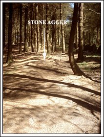
Take the agger above, for example, which can be found running up the west slope of Beacon Fell towards its summit.
Now, previously, somewhere…don’t ask us where…we postulated that the Ribchester to Lancaster Roman road around this district might not follow Snape Rake Lane as suggested by Philip Graystone at all but might actually cross Beacon Fell. Our reasoning ran thus: ‘Anthony Hewitson in his book ‘Northwards’ recalls that the owner of Beacon Fell House, whilst repairing a wall behind the property, uncovered what he believed was a Roman road. Beacon Fell House originally stood halfway up the west slope and could, with a certain amount of imagination, lie directly on the Ribchester to Lancaster route.’
However, here’s another possibility.
It’s just possible that the owner of Beacon Fell House didn’t uncover a Roman road at all but an Old Way suggesting, perhaps, that Beacon Fell harbours some sort of prehistoric settlement on its summit.
This isn’t as ridiculous as it might at first sound. Beacon Fell, unlike all the other fells in the Wyre, stands alone, its summit commanding a 360 degree view of the surrounding landscape. This would, of course, have made an ideal place for a fortified village.
So, let’s get back to that narrow agger running up the fell-side; an agger that, hopefully, the photograph below demonstrates is chock full of water-washed stones.
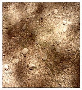
Actually the photograph doesn’t do the construction of the road any justice at all so, unless you want to track down the agger for yourselves, you’ll just have to take our word for it.
We ought to point out, perhaps, that not everybody we discussed the agger with was convinced that we’d actually found a track. Well, when we say ‘not everybody’ we refer, of course, to Neil Thompson who believed instead that the agger was the result of forestry work conducted by Wyre Rangers. Apparently the rangers employ a method of banking earth in this manner to help the fir trees grow. We’ve never actually heard of such a practice although, it must be said, some of the trees straddling the agger reach at least 60 feet in height. Having said that, so do the trees surrounding it for acres on either side so, for the time being at least, we’ll have to agree to disagree with Neil on this particular score.
In our opinion there’s far too much stone in the agger to have occurred naturally during digging and, because those stones all appear to be beach or river pebbles, we can only assume they were brought in for the purposes of track construction. Besides, it’s the only long straight mound we could find on the fell (although, we have to admit, we didn’t look terribly hard) and…well…to be honest the rest of the trees seem to be doing fine without other embankments to aid their growth.
Whatever the case we followed the ‘agger’ virtually to the summit where, criss-crossed by modern paths and ditches, we managed to lose it.
The summit itself is full of bumps and mounds and rabbit burrows which, should the visitor crouch down on their hands and knees and check with a torch, appear to contain layers of stone. Evidence of prehistoric construction?
Well, therein lies the problem. Exactly how much of Beacon Fell has been modified for public use by the Wyre Rangers over the last few decades we couldn’t say so unless a palstave or some other prehistoric implement emerges from the summit we’ll never know what’s modern and what isn’t.
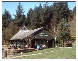
Just to return to Hewitson’s ‘Northwards’ before we leave this subject alone, the book informs us that the road discovered behind Beacon Fell house (now the Visitor Centre shown below) actually split in two, one fork heading around the slope whilst the other (apparently) struck out towards the summit.
Assuming the road was an ‘Old Way’ if we were to follow it to the north then, before much longer, it would meet the Ribchester to Lancaster Roman road at Broadgate. As we’ve mentioned before ‘gates’ are ancient roadways leading to destinations described by the preceding word. For example ‘Galgate’ is the ‘gate’ to ‘Galacum’ (the Roman name for Lancaster), whereas Watery Gate is the ‘Gate’ that leads to ‘The River’. Similarly, therefore, Broadgate suggests a narrow road leading to a much broader one and, if we’re correct, then this would seem appropriate. Old Ways were much narrower than Roman roads (six to eight feet across as opposed to twenty-odd feet).
All of which makes you think, doesn’t it? Was there an Iron Age fort on Beacon Fell, complete with a series of pebble tracks? For the time being, of course, we’ll just have to speculate until we can prove it one way or another…and that might take some considerable time.
Take the agger above, for example, which can be found running up the west slope of Beacon Fell towards its summit.
Now, previously, somewhere…don’t ask us where…we postulated that the Ribchester to Lancaster Roman road around this district might not follow Snape Rake Lane as suggested by Philip Graystone at all but might actually cross Beacon Fell. Our reasoning ran thus: ‘Anthony Hewitson in his book ‘Northwards’ recalls that the owner of Beacon Fell House, whilst repairing a wall behind the property, uncovered what he believed was a Roman road. Beacon Fell House originally stood halfway up the west slope and could, with a certain amount of imagination, lie directly on the Ribchester to Lancaster route.’
However, here’s another possibility.
It’s just possible that the owner of Beacon Fell House didn’t uncover a Roman road at all but an Old Way suggesting, perhaps, that Beacon Fell harbours some sort of prehistoric settlement on its summit.
This isn’t as ridiculous as it might at first sound. Beacon Fell, unlike all the other fells in the Wyre, stands alone, its summit commanding a 360 degree view of the surrounding landscape. This would, of course, have made an ideal place for a fortified village.
So, let’s get back to that narrow agger running up the fell-side; an agger that, hopefully, the photograph below demonstrates is chock full of water-washed stones.
Actually the photograph doesn’t do the construction of the road any justice at all so, unless you want to track down the agger for yourselves, you’ll just have to take our word for it.
We ought to point out, perhaps, that not everybody we discussed the agger with was convinced that we’d actually found a track. Well, when we say ‘not everybody’ we refer, of course, to Neil Thompson who believed instead that the agger was the result of forestry work conducted by Wyre Rangers. Apparently the rangers employ a method of banking earth in this manner to help the fir trees grow. We’ve never actually heard of such a practice although, it must be said, some of the trees straddling the agger reach at least 60 feet in height. Having said that, so do the trees surrounding it for acres on either side so, for the time being at least, we’ll have to agree to disagree with Neil on this particular score.
In our opinion there’s far too much stone in the agger to have occurred naturally during digging and, because those stones all appear to be beach or river pebbles, we can only assume they were brought in for the purposes of track construction. Besides, it’s the only long straight mound we could find on the fell (although, we have to admit, we didn’t look terribly hard) and…well…to be honest the rest of the trees seem to be doing fine without other embankments to aid their growth.
Whatever the case we followed the ‘agger’ virtually to the summit where, criss-crossed by modern paths and ditches, we managed to lose it.
The summit itself is full of bumps and mounds and rabbit burrows which, should the visitor crouch down on their hands and knees and check with a torch, appear to contain layers of stone. Evidence of prehistoric construction?
Well, therein lies the problem. Exactly how much of Beacon Fell has been modified for public use by the Wyre Rangers over the last few decades we couldn’t say so unless a palstave or some other prehistoric implement emerges from the summit we’ll never know what’s modern and what isn’t.
Just to return to Hewitson’s ‘Northwards’ before we leave this subject alone, the book informs us that the road discovered behind Beacon Fell house (now the Visitor Centre shown below) actually split in two, one fork heading around the slope whilst the other (apparently) struck out towards the summit.
Assuming the road was an ‘Old Way’ if we were to follow it to the north then, before much longer, it would meet the Ribchester to Lancaster Roman road at Broadgate. As we’ve mentioned before ‘gates’ are ancient roadways leading to destinations described by the preceding word. For example ‘Galgate’ is the ‘gate’ to ‘Galacum’ (the Roman name for Lancaster), whereas Watery Gate is the ‘Gate’ that leads to ‘The River’. Similarly, therefore, Broadgate suggests a narrow road leading to a much broader one and, if we’re correct, then this would seem appropriate. Old Ways were much narrower than Roman roads (six to eight feet across as opposed to twenty-odd feet).
All of which makes you think, doesn’t it? Was there an Iron Age fort on Beacon Fell, complete with a series of pebble tracks? For the time being, of course, we’ll just have to speculate until we can prove it one way or another…and that might take some considerable time.


2 comments:
Imagine if you will, a jigsaw puzzle. You have to find all the right pieces and put them together.
Now imagine that on top of this puzzle lies another puzzle, and on top of that another puzzle, and on top of that another. So now whenever you find a puzzle piece, you don't know exactly which puzzle it belongs to.
Now imagine that the makers of the top puzzles were able to use pieces from the bottom puzzles, modifying them for their own use, so that the bottom most puzzles now have missing pieces, or pieces that seem to fit but now have different pictures on them.
Oh yeah, and as time goes by, man and nature actually remove some of the pieces, and toss them in the bin.
Now that's what you're dealing with, when you try to piece together the history of the Wyre.
Am I close?
Do I get points for the most uses of the word 'puzzle' in a blog response?
The weird thing is, I actually envy you. I wish I could be there to help solve this impossible puzzle.
Good luck, and keep posting. And speaking of Anglo-Saxon boundary markers... ( Posting... posts... )how about some pictures of those, eh?
Cheers, JOHN :0)
John,
I prefer to think of it more being more like a Zelda game...only without so many skeletons to battle and the puzzles are a bit harder. But, in essence, you've hit the nail on the head.
As for the Anglo-Saxon Boundary Markers...I'll get onto them as soon as poss.
Post a Comment