For once the government seems to have done something right. It’s a little known fact that in September 2005 huge swathes of the Wyre previously off-limits to the Great British public were opened up to ramblers and curious archaeologists alike, allowing them the chance to roam where they had previously been forbidden.
For instance, open spaces such as Hayshaw Fell, formerly the grouse-shooting reserve of the Duke of Westminster, are now accessible by all and sundry…at least for eleven months out of the year, twenty-eight days per annum still being devoted to aristocrats bravely blasting those dangerous grouse out of the heather. Nonetheless, this is excellent news because such haunts are bound to contain some never-before-recorded archaeology, integral to understanding the history of the Wyre. (For more information concerning the new-rights-to-roam scheme we recommend that you visit http://www.countrysideaccess.gov.uk.)
Bearing all of that in mind, let’s return to Hayshaw Fell…or at any rate in the first instance nearby Harrisend Fell, and a little known reference by Henry Taylor in his ‘Ancient Crosses of Lancashire’ concerning the well of St. Elyn: “It is a beautiful cold spring which is at the side of ‘Bonny Pad,’ a pathway leading across the moor from Harris End, and it was grown around with rushes…All I can glean about it is that one of the oldest inhabitants, when asked if he knew of it, replied, ‘It will be th’ holy well, you mean.’”
With names like St. Elyn (a Celtic goddess) and Bonny Pad (Anglo-Saxon for the ‘Summoning’ or ‘Communication Road’) naturally we were intrigued and tracked the site of this antique spring down on the 1843 OS map.
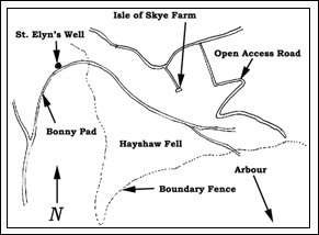
Having done this we realised that the ‘Bonny Pad’ by the side of which St. Elyn’s Well sat, actually ran up Harris End Fell, along the top of Hayshaw Fell, across Catshaw Fell and towards Greave Clough Head.
Now there’s a name! The word ‘clough’ derives from the Saxon verb ‘Cleave’ meaning, quite literally, to cleave. ‘Cloughs’, it therefore follows, are huge clefts in the fellsides. The word ‘greave’ on the other hand is Saxon for ‘barrow’ from which our modern word ‘grave’ originates. (Think Yolrungegreve and you’re on the right lines.) So Greave Clough becomes the ‘Ravine of the Barrows’ and, sure enough, scattered all around Greave Clough Head are numerous mounds recorded on large-scale Ordnance Survey maps, along with standing stones and cairns.
If that wasn’t intriguing enough, then Bonny Pad, an obviously ancient highway most likely dating from the pre-Roman period as indicated by the presence of the aforementioned St. Elyn’s Well, appears to have run to Greave Clough Head itself before vanishing into the fells, heading in the general direction of Yorkshire.
All of which, we’re sure you’ll agree, is fascinating…and there we would have had to leave the subject if it hadn’t been for the new Open Access laws. Obviously, with a chance to pin down our ancient history more accurately, we decided to visit Hayshaw Fell for ourselves.
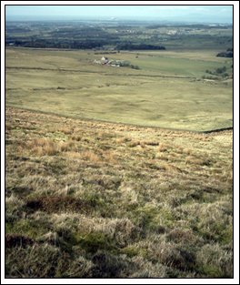
So, one late February morning in 2006 (and trust us, February isn’t the best time of year for hiking up a one-and-a-half-thousand foot high fell…especially with a combination of gout, high blood pressure, diabetes and back problems between us) Lynne Lancaster and ourselves drove to the Open Access gate just east of Isle of Skye Farm (shown in the photograph below) and began the long ascent, armed only with a handful of egg butties, two bottles of Vanilla flavoured Coca-Cola, a rather badly photocopied map and a compass that we’d bought from Poundstretcher in Fleetwood.
Unfortunately, at a height of approximately 800 feet Lynne had to abandon the struggle, leaving us to continue alone, rather stupidly forgetting our rucksack in the process…and, as a consequence, the map, the sandwiches and the somewhat cheap compass.
Once on the summit, however, we made our way towards the boundary fence (with its enigmatic cairns) against sub-artic conditions, fell down three ditches (very much relieved to discover that the heather growing in them was springy and comfortable) and disturbed several noisy grouse in the process.
And, what did we find?
Well…Bonny Pad, of course.
Only it wasn’t exactly what we’d been expecting. Take a look at the photograph below and you’ll probably see what we mean.
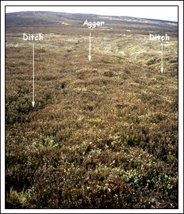
Although the road itself might not be terribly clear in such a low resolution photograph, in reality it was huge, measuring twenty to thirty feet across with another six feet on either side for the ditches. (These were the same ditches that we’d managed to fall down several times before realising what they actually were.)
The road surface was cambered and clearly constructed from quarried stones, large numbers of which were visible through the soil and heather. Larger stones occupied the base with smaller chippings on the top.
The outer banks were, in places, shored up by even larger boulders.
So, are you thinking what we were thinking yet? Well…it seems to us that Bonny Pad wasn’t just an ancient Celtic road but was, in fact, a major Roman military artery. Not only that, but on the summit of Hayshaw Fell as we soon discovered it formed a junction with a second Roman road of equal grandeur running south towards the River Calder.
But where exactly was the main thrust of this highway heading? Well, we know from maps (and Henry Taylor) that to the west it curved around Harris End Fell, deliberately passing St. Elyn’s Well en route. Then, presumably, it connected to the ‘Ribchester – Lancaster’ highway, recorded by numerous historians over the years.
To the east, however, we don’t the route yet know. Our ears were fast turning brittle due to the biting cold and our fingers had become a disturbing shade of blue. So we were forced to admit defeat and return to base camp. Once reunited with the map, however, we realised that the most obvious port of call for the branch road to the south was the appropriately named ‘Arbour’…also mentioned in passing in Taylor’s ‘Ancient Crosses of Lancashire’.
‘Arbour,’ of course, was a Roman word describing a place of shelter, which, tucked away as it is in the valley close to the source of the Calder, would explain a great deal.
Just for the record, we also photographed a couple of the ‘cairns’ that could be found dotted along the boundary fence. As you can see from the photograph below they weren’t exactly massive but they were, apparently, impressive enough to warrant inclusion on the OS maps.
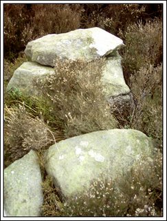
Exactly what part they had to play in the history of Bonny Pad we’re not as yet certain.
On the return leg of our jaunt Lynne also noticed a large circle in the landscape near Isle of Skye Farm. (It’s amazing what features can be seen from such an altitude.) Again, as yet we’re uncertain what relevance this might actually have. The fact that Bonny Pad was a Roman road, and a major one at that, we’re almost certain. The evidence is there…although obviously a return visit is in order to confirm this. Other standing stones, cairns, greaves and points of archaeological interest abound in this area so, now that it’s open season for adventurous explorers such as us, you can bet your life that we’ll be returning in the not-too-distant future.
For instance, open spaces such as Hayshaw Fell, formerly the grouse-shooting reserve of the Duke of Westminster, are now accessible by all and sundry…at least for eleven months out of the year, twenty-eight days per annum still being devoted to aristocrats bravely blasting those dangerous grouse out of the heather. Nonetheless, this is excellent news because such haunts are bound to contain some never-before-recorded archaeology, integral to understanding the history of the Wyre. (For more information concerning the new-rights-to-roam scheme we recommend that you visit http://www.countrysideaccess.gov.uk.)
Bearing all of that in mind, let’s return to Hayshaw Fell…or at any rate in the first instance nearby Harrisend Fell, and a little known reference by Henry Taylor in his ‘Ancient Crosses of Lancashire’ concerning the well of St. Elyn: “It is a beautiful cold spring which is at the side of ‘Bonny Pad,’ a pathway leading across the moor from Harris End, and it was grown around with rushes…All I can glean about it is that one of the oldest inhabitants, when asked if he knew of it, replied, ‘It will be th’ holy well, you mean.’”
With names like St. Elyn (a Celtic goddess) and Bonny Pad (Anglo-Saxon for the ‘Summoning’ or ‘Communication Road’) naturally we were intrigued and tracked the site of this antique spring down on the 1843 OS map.
Having done this we realised that the ‘Bonny Pad’ by the side of which St. Elyn’s Well sat, actually ran up Harris End Fell, along the top of Hayshaw Fell, across Catshaw Fell and towards Greave Clough Head.
Now there’s a name! The word ‘clough’ derives from the Saxon verb ‘Cleave’ meaning, quite literally, to cleave. ‘Cloughs’, it therefore follows, are huge clefts in the fellsides. The word ‘greave’ on the other hand is Saxon for ‘barrow’ from which our modern word ‘grave’ originates. (Think Yolrungegreve and you’re on the right lines.) So Greave Clough becomes the ‘Ravine of the Barrows’ and, sure enough, scattered all around Greave Clough Head are numerous mounds recorded on large-scale Ordnance Survey maps, along with standing stones and cairns.
If that wasn’t intriguing enough, then Bonny Pad, an obviously ancient highway most likely dating from the pre-Roman period as indicated by the presence of the aforementioned St. Elyn’s Well, appears to have run to Greave Clough Head itself before vanishing into the fells, heading in the general direction of Yorkshire.
All of which, we’re sure you’ll agree, is fascinating…and there we would have had to leave the subject if it hadn’t been for the new Open Access laws. Obviously, with a chance to pin down our ancient history more accurately, we decided to visit Hayshaw Fell for ourselves.
So, one late February morning in 2006 (and trust us, February isn’t the best time of year for hiking up a one-and-a-half-thousand foot high fell…especially with a combination of gout, high blood pressure, diabetes and back problems between us) Lynne Lancaster and ourselves drove to the Open Access gate just east of Isle of Skye Farm (shown in the photograph below) and began the long ascent, armed only with a handful of egg butties, two bottles of Vanilla flavoured Coca-Cola, a rather badly photocopied map and a compass that we’d bought from Poundstretcher in Fleetwood.
Unfortunately, at a height of approximately 800 feet Lynne had to abandon the struggle, leaving us to continue alone, rather stupidly forgetting our rucksack in the process…and, as a consequence, the map, the sandwiches and the somewhat cheap compass.
Once on the summit, however, we made our way towards the boundary fence (with its enigmatic cairns) against sub-artic conditions, fell down three ditches (very much relieved to discover that the heather growing in them was springy and comfortable) and disturbed several noisy grouse in the process.
And, what did we find?
Well…Bonny Pad, of course.
Only it wasn’t exactly what we’d been expecting. Take a look at the photograph below and you’ll probably see what we mean.
Although the road itself might not be terribly clear in such a low resolution photograph, in reality it was huge, measuring twenty to thirty feet across with another six feet on either side for the ditches. (These were the same ditches that we’d managed to fall down several times before realising what they actually were.)
The road surface was cambered and clearly constructed from quarried stones, large numbers of which were visible through the soil and heather. Larger stones occupied the base with smaller chippings on the top.
The outer banks were, in places, shored up by even larger boulders.
So, are you thinking what we were thinking yet? Well…it seems to us that Bonny Pad wasn’t just an ancient Celtic road but was, in fact, a major Roman military artery. Not only that, but on the summit of Hayshaw Fell as we soon discovered it formed a junction with a second Roman road of equal grandeur running south towards the River Calder.
But where exactly was the main thrust of this highway heading? Well, we know from maps (and Henry Taylor) that to the west it curved around Harris End Fell, deliberately passing St. Elyn’s Well en route. Then, presumably, it connected to the ‘Ribchester – Lancaster’ highway, recorded by numerous historians over the years.
To the east, however, we don’t the route yet know. Our ears were fast turning brittle due to the biting cold and our fingers had become a disturbing shade of blue. So we were forced to admit defeat and return to base camp. Once reunited with the map, however, we realised that the most obvious port of call for the branch road to the south was the appropriately named ‘Arbour’…also mentioned in passing in Taylor’s ‘Ancient Crosses of Lancashire’.
‘Arbour,’ of course, was a Roman word describing a place of shelter, which, tucked away as it is in the valley close to the source of the Calder, would explain a great deal.
Just for the record, we also photographed a couple of the ‘cairns’ that could be found dotted along the boundary fence. As you can see from the photograph below they weren’t exactly massive but they were, apparently, impressive enough to warrant inclusion on the OS maps.
Exactly what part they had to play in the history of Bonny Pad we’re not as yet certain.
On the return leg of our jaunt Lynne also noticed a large circle in the landscape near Isle of Skye Farm. (It’s amazing what features can be seen from such an altitude.) Again, as yet we’re uncertain what relevance this might actually have. The fact that Bonny Pad was a Roman road, and a major one at that, we’re almost certain. The evidence is there…although obviously a return visit is in order to confirm this. Other standing stones, cairns, greaves and points of archaeological interest abound in this area so, now that it’s open season for adventurous explorers such as us, you can bet your life that we’ll be returning in the not-too-distant future.


2 comments:
The whole article is indeed fascinating, and makes me even sadder that I didn't make it out to the Wyre on my last trip to the UK.
It is wonderful that people like you, that are preserving the area's history, now have access to the area, but I hope that treasure hunters and the like don't spoil that history now that they too have access.
I'm sure that not every treasure hunter subscribes to to the Portable Antiquities Scheme, and even those that do may misplace important artifacts that could help date or otherwise identify ancient sites.
In other words, get out there you lazy duffs, and preserve that history while it's still there to preserve!
PS I have to ask, does Harris End have anything to do with the Harris of Harris & Hughes?
PSS I look forward to your next installment. Can you please include more photos of standing stones, cairns, etc?
Thanks, JOHN :0)
John,
To the best of my knowledge Harris End has nothing whatsoever to do with Michelle. (If I said that, in some respects, the fell might resemble her rear end my life wouldn't be worth living. Certain light-hearted remarks just simply aren't worth making.)
I'll try to dig out more cairns and standing stone photographs for next week.
Post a Comment